

JICA–OFSDP Forest Survey & Mapping Project
SpatiEdge draws its foundation from professional participation in the execution of large-scale, flagship geospatial mission projects, contributing to survey integration, GIS database development, and decision-ready spatial outputs for government programmes.

Project Overview
The JICA–OFSDP Forest Survey & Mapping Project was executed by SpatiEdge Technologies Pvt. Ltd. to provide high-precision forest mapping and geospatial intelligence for the Odisha Forestry Sector Development Project (OFSDP), supported by JICA. The project aimed to strengthen sustainable forest management, improve monitoring, and support decision-making for conservation and development initiatives.
Client / Stakeholders
Japan International Cooperation Agency (JICA) – OFSDP
Government of Odisha – Forest Department
Project Objectives
Establish accurate forest boundary and compartment maps
Support sustainable forest management and planning
Digitize and geo-reference legacy forest maps
Ensure compliance with international project standards
Scope of Work
DGPS-based forest boundary and compartment surveys
Digitization and geo-referencing of existing forest maps
Creation of GIS layers for forest compartments, resources, and infrastructure
Integration of survey data with management and monitoring systems
Methodology & Technical Approach
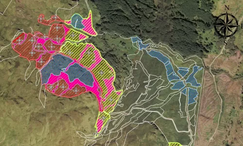
SpatiEdge applied a combination of DGPS field surveys and GIS digitization techniques to ensure high positional accuracy. Legacy forest maps were geo-referenced and harmonized with new survey data. GIS layers were created to represent forest boundaries, compartments, and associated attributes, enabling precise monitoring and sustainable planning.
Technologies & Tools
DGPS / GNSS Survey Systems
GIS Platforms (ArcGIS / QGIS)
Remote Sensing Analysis
CAD–GIS Integration
Key Deliverables
Geo-referenced forest boundary and compartment GIS layers
Digitized forest maps with detailed attributes
GIS databases for forest management planning
Technical documentation and validation reports
Impact & Outcomes
Improved accuracy and clarity of forest boundaries
Strengthened forest monitoring and management
Enhanced planning for sustainable forestry initiatives
Compliance with JICA and international project standards